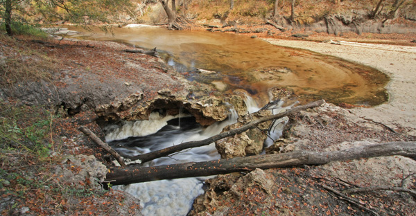
Sinkholes that occur in river channels are conduits through which surface water can rapidly enter into the Floridan aquifer system. Some conduit systems may drain surface water from a river in one location and return it at another location through features known commonly as river rises. Some river rises, such as the St. Marks Rise, discharge large quantities of groundwater in addition to river water. Click here to watch a video of Dover Sink draining water from the Peace River near Bartow, Florida at rate of approximately 10 million gallons per day (15 cubic feet per second).
The study comprises six major tasks. Each task is listed below followed by a bulleted description. For selected tasks, the last bullet indicates published products for the respective task and will be updated periodically as products are released.
Compile Geospatial Data Library
- Compile and geo-reference historical data for the Floridan aquifer system.
- Develop digital base maps for working maps, presentations, publications, and hydrologic modeling, and provide geospatial data support for hydrologic modeling, visualization, and analysis of numerical modeling results.
- Several reports have been completed documenting spatial datasets of hydrogeologic surfaces and geophysical and hydrologic data (Bellino, 2011; Kinnaman, 2011; Kuniansky and Bellino, 2012; Williams and others, 2013); links to these reports are also listed on the Study Products page.
Assemble Revised Hydrogeologic Framework
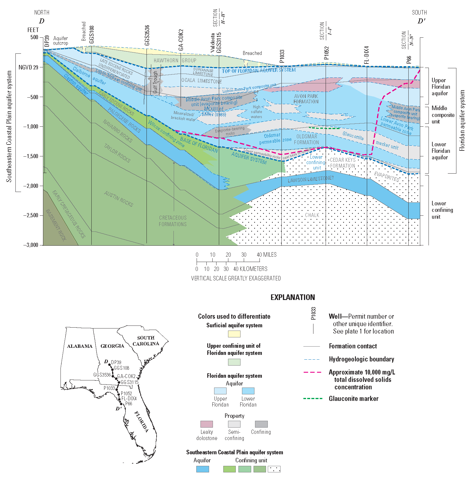
Cross-section D-D', from Williams and Kuniansky (2015).
- Revise the regional hydrogeologic framework for the Floridan aquifer system as originally defined by Miller (1986) by incorporating new studies and data and by addressing differences in local aquifer nomenclatures.
- Assemble structural surfaces and cross sections.
- Describe the groundwater hydraulics of the aquifers and confining units and develop a database of hydraulic properties.
- Map the location of the saltwater/freshwater interface across the Floridan aquifer system.
- Several reports related to the revised framework have been completed (Williams and Gill, 2010,; Kuniansky and Bellino, 2012, Kuniansky and others, 2012; Williams and others 2013; Williams and Kuniansky, 2015; Williams and Dixon, 2015); links to these reports are also listed on the Study Products page.
- Read more about the hydrogeologic framework.
Estimate Hydrologic Budgets
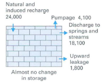
From Johnston, 1999.
- Develop independent system-wide water budgets for pre-development and post-development (19952010) conditions for the Floridan aquifer system. Subregional water budgets for delineated subareas (areas that behave somewhat independently) will be summarized based on previous modeling studies.
- Quantify natural and human derived aquifer inflows and outflows and changes in storage of water in the aquifer.
- Develop a system-wide potentiometric map of the Upper Floridan aquifer for MayJune 2010 conditions.
- Several reports related to the hydrologic budget have been completed (Kinnaman, 2011; Kinnaman and Dixon, 2011; Willams and others, 2011a, 2011b; Bellino and others, in press); links to these reports are also listed on the Study Products page.
Develop Conceptual Model of Groundwater System
- Develop an updated representation of the overall groundwater flow system based on previous studies and the compiled data from previous tasks (revised hydrogeologic framework and water budgets). The revised conceptual model will be a simplified representation of the Floridan aquifer system; however, it will contain enough detail to assure that the overall behavior of the aquifer system is reproduced.
- Characterize and describe the conceptual model for delineated subareas.
- Use the conceptual model to develop the numerical groundwater model and for analysis of the simulated water budgets for the entire Floridan aquifer system and delineated subareas.
Construct Numerical Model of Regional Groundwater System
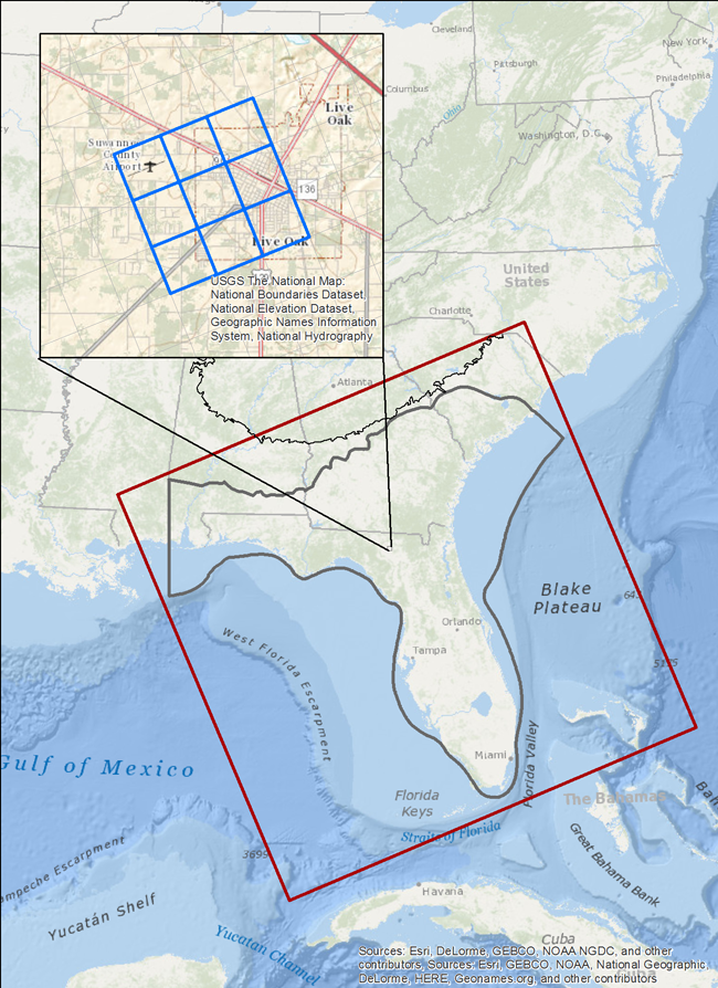
Extent of numerical model grid with inset showing size of proposed 1 mile by 1 mile grid.
- Even though numerous numerical models of the Floridan aquifer system of varying sizes have been developed, there has yet to be a model developed of the entire Floridan aquifer system since the Regional Aquifer-System Analysis (RASA) study nearly 30 years ago (Bush, 1982; Bush and Johnson, 1988). A system-wide, numerical model of the Floridan aquifer system can be used as a tool to understand the overall groundwater flow system.
- Develop the numerical model with MODFLOW-2005, using approximately the same horizontal boundaries as the regional model for the RASA study (Bush, 1982; Bush and Johnson, 1988), and including parts of the surficial and intermediate aquifer systems and the entire Floridan aquifer system (fresh to brackish water zones). Large-scale movements of the freshwater-saltwater interface will be tracked using the Seawater Intrusion (SWI) package.
- Perform automated calibration using formal inverse modeling techniques with spatially varying parameterization chosen according to the conceptual model.
- Further details are available on the Numerical Model page.
Assess Groundwater Availability
- The phrase groundwater availability may be interpreted differently among the target audience of this study. For example, a regulatory agency may interpret it to have some connection with a regulatory criterion. In Florida, the water management districts have set minimum flows and levels for rivers and lakes which are meant to protect the resources from significant harm. In this context, groundwater availability conveys the idea that there is a known quantity of groundwater that we may withdraw without exceeding this criterion. The USGS, a non-regulatory agency, will present an impartial, un-biased scientific assessment of the resource while avoiding such regulatory implications. To this end, availability of groundwater will refer to the general effects of natural and anthropogenic stresses on the system in terms of how they may affect the amount and/or spatial distribution of fresh water in the system. These findings will be discussed and then summarized in the context of groundwater depletion, saltwater intrusion, and groundwater divide migration.
- Predevelopment to current conditions: The groundwater model will be used to create water budgets and head-change maps for the FAS. Evaluation of historic and current conditions will focus primarily on the cumulative effects of groundwater withdrawals on the water budget. Water budgets will be used to show how groundwater development has altered system dynamics in terms of changes in fluxes through the FAS. For example, during predevelopment, recharge and discharge were equal to one another over a long-term average and there were, therefore, no changes in storage over time. When water is removed from the system by pumping, it is replaced by increased recharge, decreased discharge to other parts of the system, and by removal of water from storage. Head change maps will be used to show the spatial distribution of changes in the groundwater flow system. Areas in which heads have decreased over time will be compared and contrasted with areas where heads have remained relatively stable.
- Potential future conditions: Evaluation of projected future conditions will focus on the anticipated effects of (1) climate change, (2) sea-level rise, and (3) increased groundwater demand with respect to the degree to which they may affect the problems and issues outlined above (groundwater depletion, saltwater intrusion, and groundwater divide migration).
- Apply spatial and temporal water budgets from the model to determine short-term and long-term effects on water availability in different areas of the Floridan aquifer system resulting from potential future stresses as inferred from climate variability, sea-level rise, and increased groundwater demand simulations. Comparing these past, present, and future water budgets and changes in groundwater discharge to streams and springs in different locations of the Floridan aquifer system can provide information on which areas are most vulnerable to potential future changes in climate, sea-level, and population growth.
- The model will also be used to evaluate current monitoring networks (groundwater level and spring flow) and to provide guidance for selecting future monitoring networks. Such guidance may be used to inform development of USGS groundwater monitoring networks, such as those funded through the Cooperative Water Program, as well as networks maintained by other Federal agencies and state and local agencies.
Groundwater availability will be assessed for: